Agro-Climatic Zones
The National Agricultural Research Project was launched in 1979 by the Indian Council of Agricultural Research (ICAR) for agro climatic zonation or ecological land classification. It listed 126 zones.
- The National Bureau of Soil Survey & Land Use Planning (NBSS&LUP) in 1992 gave twenty agro-ecological zones based on the growing period as an integrated criterion of effective rainfall, soil groups, delineated boundaries adjusted to district boundaries with a minimal number of regions.
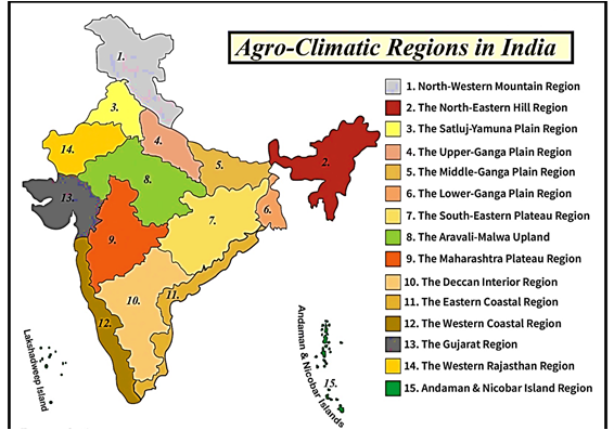
- Finally, in 1988, the Planning Commission divided India into 15 agro-climatic regions with 73 sub-regions.
Important Facts
Do You Want to Read More?
Subscribe Now
To get access to detailed content
Already a Member? Login here
Take Annual Subscription and get the following Advantage
The annual members of the Civil Services Chronicle can read the monthly content of the magazine as well as the Chronicle magazine archives.
Readers can study all the material since 2018 of the Civil Services Chronicle monthly issue in the form of Chronicle magazine archives.
Geography Of India
- 1 Coastal and Desert Landforms of India
- 2 Origin and Characteristics of Major River Systems
- 3 Integrated River Basin Governance
- 4 Interlinking of Rivers and their Ecological-Economic Trade-offs
- 5 Groundwater Stress Mapping
- 6 Patterns of Regional Disparities and Spatial Development in India
- 7 India’s Strategic Location in the Global and Regional Contexts
- 8 Geological Evolution of the Indian Subcontinent
- 9 India’s Geological Uniqueness: Some Salient Aspects
- 10 Peninsular Block, Himalayan Region, and Indo-Gangetic Plains: Comparative Features
